Day 2
September 10, 2005
This day started off the same as the last with rain coming down and 50 degrees. Everything went along just fine for the first fifty miles and then it turned into the trip from hell!!! We felt sort of like Gilligan's Island, with their "three hour tour". It was supposed to take us four and a half hours to go from our camp spot to Glacier Park but it ended up being eight and a half hours thanks to our DeLorme mapping software. We use DeLorme Atlas to plan our trip and plug our GPS into the computer to map our progress. There's a nice ladies voice that directs you along your route telling you where to turn.
Long before we left home I plotted our course and everything looked really good. When we followed the route today things got a little strange when we didn't make a turn. The nice ladies voice from DeLorme on the computer said we missed a turn but we never even saw it. We turned around and went back and sure enough she was right. There was a gravel road that we had missed. It sure didn't look like a road we'd want to take but to go another way from where we were at would take an additional hour and a lot of back tracking.
We started heading up the gravel road and it wasn't too bad for the first few miles. Then it got narrower and rougher, still we kept going. Then it got narrower, rougher and steeper and we started wondering if it was the right thing to do. About eight miles in the road really got ugly! The kind of roads that you go on with a four wheel drive Jeep only we are pulling a trailer with a two wheel drive pickup.
We are now down to about five miles per hour or less, dodging fallen trees, rocks and big ruts. No place to turn around even if we wanted to. We were stuck, no place to go but onward. As remarkable as it seems the nice DeLorme lady kept talking us along the road, "left at No Name road 1.2 miles. You'll arrive in 30 seconds". Well it would take us ten minutes to go those 1.2 miles but sure enough there would be another road if you want to call it that.
She missed one turn to Silver Butte Pass where she said to turn but there was no road. That really had us scared because we were deep into it and no place to turn around. We slogged on ahead and about a quarter mile up the road there was a road and a sign that said Silver Butte Pass 5 Miles. That's when things REALLY got ugly!
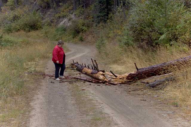
This road was not only steep, narrow, rocky and rutty, in a really steep part it was broken shale, not good for traction. I got a run at it and while the wheels were spinning they pulled us on through it. Not more than a quarter mile later we came around an especially tight hairpin turn and there's a big tree down in the road, crap!
To back up out of there would have been all but impossible. It was a pretty good sized tree, about eighteen inches in diameter. The tree broke close to the edge of the road but it wouldn't roll because of the limbs sticking out. So I broke out the hatchet I gave Marilyn over twenty years ago (how's that for fate) and we begin chopping branches off so we could roll it. After a bit of chopping we gave it a roll and got it far enough off the road so that we could pass, whew!
There were many trees that had bent over toward the road and had been chopped off by the Forest Service but they still stuck out below trailer height. I was constantly worried about one of them going into the sided of the trailer and ripping a hole.
We made it over the pass but the road didn't get any better, in fact it got worse because it had been raining all day the potholes were now filled with water and you couldn't tell how deep they were and which ones to avoid. We'd slow down from 5 MPH to a crawl to go through each of them.
With ONLY thirteen miles to go, the total off road trip was twenty seven miles, we ran into a guy on a quad off road vehicle. He said that there was a pickup coming up the hill. He went back to the other pickup and told him to find a wide spot. The pickup had to back up about a quarter mile to get clear. We inched by and headed on down.
The rest of the trip was just more of the same, very hairy and slow. There were several times when it felt like the trailer wheels were starting to go over the edge. Oh yeah did I mention that besides all the other threats there was almost always a sheer cliff on one side or the other?
Four hours and twenty seven miles later we crawled out the other side. We notices a sign for people going in that read, "Two wheeled vehicles and trailers not allowed!" Now why didn't they have a sign like that on the other side?
The rest of the trip was uneventful but rainy. Actually that was good because it washed some of the mud off of our rig. The running boards on the pickup were about two inches thick with heavy mud and sand. Some of the rain had chunks of snow in it. Yes SNOW! It was around 38 degrees and even the pass in Glacier Park is closed today due to snow. We aren't going up to the pass until tomorrow or Monday and the weather is supposed to get better.
We arrived at Glacier Campground around 5:00 and it's a lovely place. There are lots of deep woods although the camp sites are fairly close together. You still get a good sense of being out in the woods. Also there is almost nobody here and that helps.

I looked the trailer over and there doesn't appear to be any damage though things inside were tossed around pretty good. Considering the situation everything turned out just fine although our nerves are totally shot and just any little thing could have given us a totally different result.
I checked the DeLorme software to see why it would have us go on such a terrible road. It turns out that I had "Forest Service Roads" check as "Acceptable" where it should have been set to "Avoid". When I set it to "Avoid" and recalculated the route it would have taken us a totally different way that wouldn't have been much longer than our original four and a half hour plan. We noticed some other changes in the rest of our trip route so I'm not sure where else it might have taken us if I didn't make the change. The DeLorme Atlas 2006 software is great but you have to be careful how you set it up and use it. By the way the GPS tracked pretty exact even through the Forest Service roads, quite amazing.
